News Flash
HANOI, Oct 8, 2025 (BSS/AFP) - Vietnam has recorded the highest flood levels on three rivers in the country's north in nearly 40 years, state media reported on Wednesday.
The high-water marks of the Bang, Thuong and Trung rivers surpassed levels not seen since 1986 from late Tuesday to Wednesday, with the latter river in Lang Son province, bordering China, forecast to peak at nearly two metres (6.5 feet) above the record, Vietnam state television said.
The level of the Bang river in Cao Bang province peaked at 11:00 pm Tuesday, "exceeding the historic flood of 1986 and is slowly receding", according to a weather news bulletin.
In Bac Ninh province, flooding at one measuring point on the Thuong river "exceeded the historic flood of 1986 and continues to rise", the bulletin said.
At another point on the same river, the water level broke a 2008 record, and was forecast to peak Wednesday night.
By Wednesday morning, Vietnam's weather bureau said the level of the Cau river, running across Thai Nguyen city, was also more than a metre higher than the previous record level -- when Typhoon Yagi devastated the country in September last year.
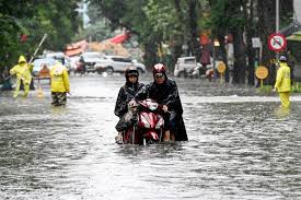
Tens of thousands of people were left stuck at home or fleeing floodwaters that reached the tops of cars and rooftops in areas of the city, about 80 kilometres north of the capital Hanoi.
The record floods have submerged streets in several communities, with at least eight people killed this week, the government said.